Falls of the Ohio State Park advisories
- The Indiana Department of Natural Resources has adjusted services, events and operations to protect Hoosiers and prevent further spread of COVID-19. Please visit on.IN.gov/dnrcovid19 for a listing of what is open, closed, restricted and canceled.
- One of the two boat ramps at the George Rogers Clark Home site, located at the Falls of the Ohio State Park, has been repaired and will be open for public use when safe conditions are present. The secondary boat ramp at the site remains closed due to significant damage that occurred during the flooding in 2018. For more information or daily updates, feel please contact Falls of the Ohio State Park at 812-280-9970 from 9 a.m.-5 p.m. Monday through Saturday and 1-5 p.m. on Sundays.
- When traveling to the park on I-65 southbound, use Exit 1 and follow directional signs.
- Description
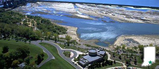
Located on the banks of the Ohio River at 201 West Riverside Drive, Clarksville, Indiana, is Falls of the Ohio State Park. The 390-million-year-old fossil beds are among the largest exposed Devonian fossil beds in the world. The park features a spectacular interpretive center overlooking the fossil beds featuring new interactive, immersive exhibits.
While fossil collecting is prohibited on the fossil beds and river bank, the park staff encourages visitors to explore and discover the many different types of fossils that can be found on the ancient sea bottom. Collecting piles (with rock and fossils from quarries) are the only place where rocks may be removed at the Falls of the Ohio. They are located by the parking lot behind the interpretive center.
The interpretive center is open Monday – Saturday, 9 a.m. to 5 p.m. and Sunday, 1 to 5 p.m. The park grounds are open 7 a.m. to 11 p.m. Fishing, hiking, fossil viewing, bird watching and picnicking are among the most popular activities. Admission is $9 age 12 & up; $7 age 5 to 11; under 5 is free. Parking is $2. The Annual Entrance Pass covers parking, not Interpretive Center admission.August through October provides the best accessibility to the 220 acres of fossil beds, as the river is at its lowest level during this period.
Stay connected
- Activities
- Trails
- Maps
- Video


