Header

Main Content

Article

Large-Scale Digital Maps (by county & quad, 2002)

This series, created to provide e-products (such as GIS coverages) for quick release, may include:

  • maps and digital coverage of bedrock surface topography and thickness of unconsolidated deposits at a scale of 1:24,000
  • maps showing potential yield of unconsolidated aquifers
  • maps showing water levels of unconsolidated and bedrock aquifers
  • hydrogeologic cross sections showing thickness and extent of unconsolidated and bedrock aquifers

Other maps and text may be added.

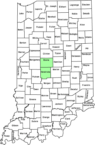
Click on shaded county for large-scale digital maps.

Note: For counties without shading, no additional large-scale mapping is currently scheduled.
State Map

Vanderburgh countyRipley countyJennings countyJackson countyDaviess countyJohnson countyMarion countyHamilton countyMadison countyGrant countyAdams countyHuntington countyWhite countyAllen countyWhitley countyFulton countyDeKalb countyStarke countyLake countyDearborn countyFayette countyHendricks countyHancock countyMonroe countyPosey countyWarrick countySpencer countyPerry countyCrawford countyHarrison countyFloyd countyClark countyScott countySwitzerland countyJefferson countyWashington countyOrange countyDubois countyPike countyGibson countyOhio countyLawrence countyMartin countyKnox countyBartholomew countyDecatur countySullivan countyBrown countyClay countyVigo countyOwen countyFranklin countyMorgan countyRush countyUnion countyWayne countyShelby countyPutnam countyParke countyVermillion countyWarren countyHoward countyWells countyClinton countyMiami countyMontgomery countyRandolph countyTipton countyTippecanoe countyJay countyWabash countyKosciusko countyNoble countyMarshall countyPulaski countyNewton countyHenry countyGreene countyDelaware countyBoone countyJasper countyFountain countyBenton countyBlackford countyCass countyCarroll countyPorter CountyLaPorte countySt. Joseph countyElkhart countyLagrange countySteuben county