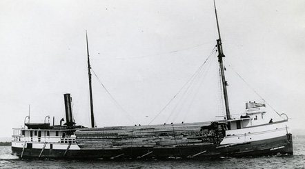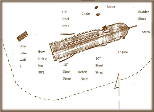
The J.D. Marshall Preserve is the first underwater preserve in Indiana. It is based around the J.D. Marshall shipwreck site. The ship sank on June 11, 1911. Why designate this as a State-dedicated nature preserve? State-dedicated nature preserves are usually on land, but many include portions of ponds and lakes, and a few include entire lakes. Some nature preserves also include cultural features. Nature preserves can be established for a variety of reasons, and one of those reasons (per the Nature Preserves Act, IC 14-31-1) is to promote understanding and appreciation of cultural values by the people of the State of Indiana.
State-dedicated nature preserves are given the highest amount of protection a tract of land can have within Indiana. The intent is to protect the preserve from any threats or conversion to another use. In this case, that primarily means keeping the J.D. Marshall in an undisturbed condition.
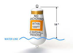
The preserve will be denoted by seasonally placed mooring buoys near the center of the preserve. There is no anchoring allowed within 1,000 feet of the mooring buoys. The NOAA nautical charts will be updated to include the boundary at a later date. The mooring buoys are located at: 1) N 41.668946 W -87.069001; 2) N 41.669081 W -87.068604; and 3) N 41.668757 W -87.068628
The preserve is approximately 100 acres. It extends from the lakebed up, to space.
Shipwrecks are more than just wood and steel beams. They tell an important story about past events and about the people who lived before us. They provide information regarding our economic, technological, and cultural history, and give us insight into early survival on the Great Lakes. Shipwrecks represent both archaeological and artistic values, and show us how the decisions we make today can affect future generations. If we preserve shipwrecks, they will be available for many to see and study for years to come.
Yes, paddling by canoe or kayak and fishing by boat with a draft less than 8 feet are both allowed; however, no anchoring is permitted by any vessels within the boundaries of the preserve for the protection of the shipwreck and surrounding debris field. DNR may place mooring buoys for fishing or diving (one boat per buoy permitted) within the boundary of the nature preserve. Use of the preserve for paddling and fishing is subject to preserve rules established by the Administrator and also subject to state fishing regulations.
The shipwreck extends above the lakebed, and anchors can catch onto important and fragile parts of the ship. Submerged cultural resources like the J.D. Marshall are nonrenewable. The damage could result in a permanent loss.
Restrictions are designed to protect the shipwreck and debris field while allowing recreation on the surface to continue as it has in the past.
- Moving, removing, injuring, possessing, or attempting to move, remove, injure, or possess, a preserve historical resource is prohibited. Per Indiana Code 14-21-1, a permit is required to conduct archaeological field investigations of historic shipwrecks on state property.
- Mineral or hydrocarbon exploration, development or production is prohibited.
- Discharging or depositing any materials or other matter from within the boundary of the preserve is prohibited.
- Divers and snorkelers must follow requirements of current state law.
- Dive boats must be of no greater tonnage than the limit of the mooring buoy—35,000 pounds of pull.
- Introducing or releasing an exotic species of plant, invertebrate, fish, amphibian, mammal, or physical objects into the preserve is prohibited.
- Marking, defacing, placing of any physical objects, or damaging in any way or displacing, removing, or tampering with any official signs, notices, or placards, whether temporary or permanent, or with any navigational aids, monuments, stakes, posts, mooring buoys, boundary buoys, trap buoys, or scientific equipment is prohibited.
The preserve is jointly managed by the DNR divisions of Nature Preserves, State Parks and Law Enforcement through an inter-division management agreement.
There are accounts of up to 50 shipwrecks within Indiana’s 241 square miles of Lake Michigan. Of those, only 14 are in known locations. Additional underwater preserves will be handled on a case-by-case basis.
 When diving within the preserve, remember to display the diver’s-down flag, follow standard safe diving practices, dive within your limits and level of training, and know both the regulations that apply to diving within the preserve and the environmental conditions. Make sure you are familiar enough with the dive site that you are able to orient yourself with your dive buddy and your surface support or boat. The preserve has a flat sandy bottom with few underwater features for navigational reference. Also, after a rain or storm, underwater visibility is reduced by outfall from local rivers. Such reduced visibility can happen while you are underwater. Therefore, you should have an underwater compass to assist with navigating within the preserve and the J.D. Marshall. Most important, all items (cultural or biological) and ship structure are owned by the State of Indiana. Removal of any items is prohibited. Take only pictures and leave only bubbles. Find additional information about diving shipwrecks on this page.
Contact a local SCUBA store for information and scuba training for diving within Lake Michigan. There are many stores in Indiana and adjacent states. Some stores offer special scuba training such as “Indiana Lake Michigan Diver” specialty SCUBA certification.
J.D. Marshall information and artifacts are displayed at the Indiana Dunes State Park Nature Center. Regular interpretive programs are also offered at the nature center. The propeller can currently be viewed from the Indiana Dunes Historic Beach Pavilion’s east side.
- This information is available in a brochure (PDF).
- Take a virtual tour of the J.D. Marshall.
- View a dive video on YouTube.

This work made possible with Section 309 financial assistance to the Indiana Lake Michigan Coastal Program under Award NA09NOS4190079, NA11NOS4190094, and NA12NOS4190092 provided by the Coastal Zone Management Act of 1972, as amended, administered by the Office for Coastal Management, National Oceanic and Atmospheric Administration.
