Main Content
Article
Road Cycling in Indiana
The road-riding environment in Indiana has improved drastically in recent years thanks to bicycle infrastructure improvements, policy changes and other measures. Indiana’s roads continue to become safer and more bicycle-friendly. Indiana offers road cyclists:
- Three U.S. Bike Routes that traverse the state.
- Hundreds of miles of bike lanes, as well as sharrows in communities across Indiana.
- A diverse landscape featuring everything from scenic, low-traffic county roads to connected, urban cycletracks.
- A robust cycling culture.
Know Before You Ride
- Indiana bicycle laws
- Share the road: Tips for bicyclists and motorists
- Bicycle safety tips
- Road cycling advocacy & recreational organizations
- 2019 Bicycle Indiana Resource Guide : Rides, organizations, retailers, & more
Where to Ride

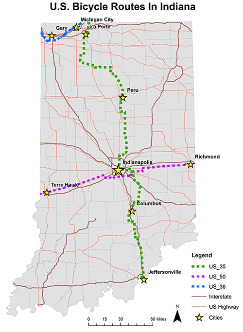
In 2015, the American Association of State Highway and Transportation Officials (AASHTO) approved three U.S. Bike Routes (USBR) for a combined 610 miles in Indiana.
The routes, which are comprised of low traffic roads, bike lanes and trails, are generally designed for experienced, long-distance or touring cyclists to travel through Indiana. However, many sections can accommodate recreational riders and commuters, too.
The routes were a partnership between INDOT, Adventure Cycling Association, Bicycle Indiana, and Hoosier Rail to Trails Council.
Learn more about each U.S. Bike Route in Indiana .
- USBR 35: 381 mile north-south route from Lake Michigan to Ohio River
- USBR 36: 58.7 mile east-west route along Lake Michigan
- USBR 50: 160 mile east-west route across central Indiana
Indiana State Roads
INDOT’s State Roadway Bike Suitability Map , completed in 2014, shows what state roads are suitable or not suitable for bicycle travel by more advanced and basic adult cyclists. This map can be a useful tool in helping cyclists to determine a safe route, especially when considering riding on a state road.
County and Local Bikeways
Many Indiana counties and communities have well-known bicycle friendly roads and bike lanes.
Below is a list by county of road routes that we know of that have maps. The maps can be either online or print, and some have cue sheets or GPX routes you can download. Some listings are designed more for recreational riders with looped routes and a set mileage. Others are intended for more utilitarian riding or those wanting to build their own bicycle-friendly route.
Additionally, some of the roads routes listed are also marked with signs or pavement markers, also known as Dan Henrys, but not all are.
Allen
Allen County & Fort Wayne
Bartholomew County
City of Columbus
Elkhart
City of Elkhart
Elkhart and St. Joseph Counties
Hamilton
City of Carmel
Kosciusko
Kosciusko County
La Porte
LaPorte County
Marion
Indy Bike Map
Monroe
Monroe County and City of Bloomington
Porter
Porter & Lake Counties
Rush
Rush County: Willkie Days '5 in 50' Covered Bridge Routes
St. Joseph County
St. Joseph and Elkhart Counties
Vanderburgh
Evansville Area
Wabash
Wabash County: Dam to Dam Route
If your community is not listed here or you are looking for more places to ride, we recommend looking at Google Maps with the bicycle layer on. It will show existing bicycle infrastructure and bicycle-friendly roads in your community. For other great places for road ride ideas, check out your local bicycle club, bicycle shop, or Strava’s Heatmap.
