Main Content
Article
Interim Digital FIRMs (2004)
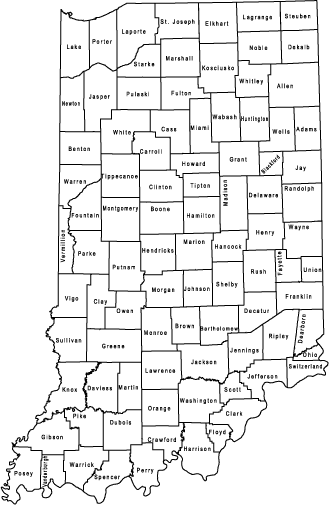
These maps are Arc View shapefiles compressed using WinZip. To download just click on the county you desire.
These data have largely been superseded by Digital Flood Insurance Rate maps published by FEMA. The official maps can be accessed at msc.fema.gov or at the Indiana Floodplain Information Portal. These data are archived here for historical and research purposes. These files should not be used for official flood insurance determination purposes nor to determine current regulatory floodplain limits. For more information see the Disclaimer (Acrobat pdf file)

Counties
- Adams
- Bartholomew
- Benton
- Blackford
- Boone
- Brown
- Carroll
- Cass
- Clark
- Clay
- Clinton
- Crawford
- Daviess
- Dearborn
- Decatur
- Delaware
- Dubois
- Elkhart
- Fayette
- Floyd
- Fountain
- Franklin
- Fulton
- Gibson
- Grant
- Greene
- Hamilton
- Hancock
- Harrison
- Hendricks
- Henry
- Howard
- Huntington
- Jackson
- Jasper
- Jay
- Jefferson
- Jennings
- Knox
- Kosciusko
- LaGrange
- LaPorte
- Lawrence
- Madison
- Marshall
- Martin
- Miami
- Monroe
- Montgomery
- Morgan
- Newton
- Noble
- Ohio
- Orange
- Owen
- Parke
- Perry
- Pike
- Porter
- Posey
- Pulaski
- Putnam
- Randolph
- Ripley
- Rush
- Scott
- Shelby
- Spencer
- St. Joseph
- Starke
- Steuben
- Sullivan
- Switzerland
- Tippecanoe
- Tipton
- Union
- Vermillion
- Vigo
- Wabash
- Warren
- Warrick
- Washington
- Wayne
- Wells
- White
- Whitley
